


Yellow warning for snow and ice across parts of the country
Register for free to read more of the latest local news. It's easy and will only take a moment.
Britons are being told to brace for potentially “hazardous conditions” as snow and ice are set for parts of the country.
The Met Office has issued yellow weather warnings for snow and ice from 5pm on Tuesday until 11am on Wednesday for parts of northern and eastern Scotland, north-east England and Yorkshire.
A separate warning is also in place from 5pm on Wednesday until 11am on Thursday for eastern Scotland and north-east England down to North Yorkshire.
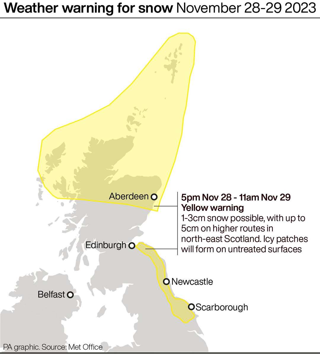
The Met Office said: “Wintry showers will lead to ice forming on untreated surfaces during Tuesday evening and overnight into Wednesday morning.
“Snow will begin to accumulate, especially away from windward coasts, with 1-3cm possible. Higher routes of north-east Scotland may see up to 5cm of snow accumulate.”
Up to 2cm of snow is possible in places overnight from Wednesday into Thursday, with 5cm over higher ground.
It is likely that some roads and railways could be hit, meaning travellers could face longer journey times by road, bus and train, according to the forecaster.
They also warned that some icy patches could form on untreated roads, pavements and cycle paths.
The UK Health Security Agency (UKHSA) has issued a yellow cold-health alert for the health sector covering northern regions of England which runs through the whole week.
Towards the end of the week there is a possibility of snow across parts of the south, according to the Met Office.
The forecaster explained that snowfall in late autumn or early winter does not generally linger – especially in southern Britain – as ground temperatures broadly remain relatively high after the summer.
David Oliver, a Met Office deputy chief meteorologist, said that after some rain on Monday, conditions will turn mainly dry in the south before there is a very uncertain period on Thursday and Friday for the southern half of England and Wales.
He said: “The weather models are highlighting several possible solutions from very wet to mainly dry, with a mainly dry picture the most probable outcome at present.
“However, some models include the prospect of an area of low pressure developing and moving in from the south or south-west.
“If this solution proves to be correct, we could see an area of warmer and moisture-laden air ‘bumping’ into the cold air further north. Along the boundary of the two air masses lies a zone across southern and central Britain where snowfall could develop fairly widely.
“Snow in any affected area is unlikely to be anything more than transient and short-lived, but it could lead to small totals and some disruption over a few hours before melting.”
RAC Breakdown spokesman Rod Dennis said the service is expecting to see “a sharp rise in breakdowns this week” as the nation is in the grip of the cold blast and car batteries falter.
He urged drivers to get their cars checked and to bring some winter gear on their journeys in case the get stuck in sub-zero temperatures.